QuakeFeed - World Earthquakes Displayed on ESRI Maps
QuakeFeed is the #1 earthquake app on the iOS App Store. Gain a unique perspective on earthquakes around the world - or quickly check on quakes affecting you or your loved ones. QuakeFeed features free nearby alerts and customizable regional alerts. Choose from either the 1-day, 7-day or 30-day USGS data feeds. A variety of filter and sort options are provided. The app is location aware so you can find quakes that are closest to you. Check out our screenshots) and read the reviews - people rave about our UI! Also features Twitter, Facebook, and email integration.
Basic Features
- Choose from USGS 1-day, 7-day, or 30-day data feeds.
- Toggle between list and map views.
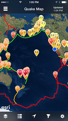
- Select from seven base map options, plus plate lines.
- Nearby alerts and custom regional alerts are free for all users (ad-supported)
- Drill down to details view.
- Detail map zooms to quake location
- Displays magnitude, time, lat/long, distance, depth
- Link to additional quake details on USGS website - Social media integration - share via Facebook, Twitter or Email.
Intuitive User Interface
- Map symbols are color-coded and sized by magnitude.
- Quake list is color-coded by magnitude.
- Sort list by date, magnitude, depth, or distance from current location.
- Specify units for distance (km or miles).
- All screens work in portrait or landscape mode.
Base Map Options
- Street Map
- Topographic Map
- Satellite Imagery
- Imagery with Labels
- Shaded Relief Map
- Physical Map
- Terrain Map
- Ocean Bathymetry